

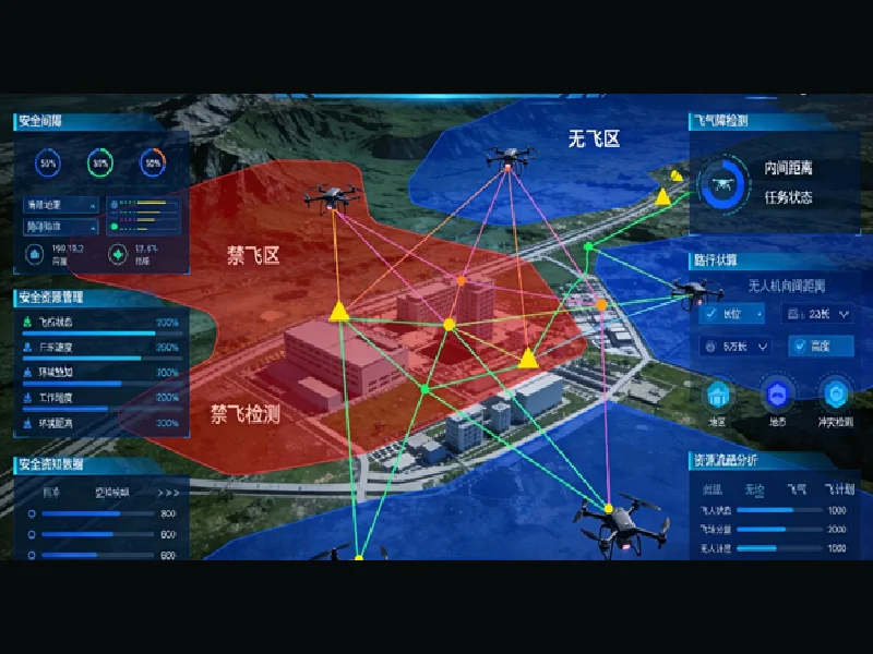
The rapid growth of the low-altitude economy is creating new opportunities for cities to improve transportation, emergency response, infrastructure inspection, and public services. However, managing increasing drone activity requires more than individual aircraft and simple monitoring tools. Cities need integrated platforms that can coordinate airspace operations, improve safety, and connect aerial resources with existing urban systems.
Low-altitude operational solutions are emerging as a critical technology foundation for smart cities. By combining 3D modeling, artificial intelligence, drone management, and real-time data connectivity, these solutions help cities build organized and scalable low-altitude ecosystems. As a spatial intelligence AI company specializing in 3D and AI technologies, Icecypress Technology develops intelligent platforms that support urban low-altitude operations through digital infrastructure, intelligent planning, and comprehensive safety management.
Why Cities Need Low-Altitude Operational Solutions
Urban environments are becoming increasingly complex, and traditional management methods are often unable to handle the growing demand for drone-based services. From infrastructure inspections to emergency response, cities require better ways to coordinate low-altitude activities while maintaining operational safety.
Low-altitude operational solutions provide a digital framework that allows governments and urban operators to manage drone activities more efficiently. These platforms integrate information from multiple sources, including geographic data, aerial devices, environmental conditions, and operational requirements.
Instead of treating drones as isolated tools, modern solutions create a connected management environment where aircraft, airspace, and ground infrastructure work together. This approach enables cities to expand low-altitude applications while maintaining visibility and control.
The Role of a Smart City Management System in Low-Altitude Development
A smart city management system provides the foundation for connecting different urban resources and improving decision-making. When combined with low-altitude technologies, it allows city managers to monitor aerial operations, analyze data, and coordinate responses through a unified platform.
For low-altitude applications, a smart city management system needs capabilities beyond traditional urban management. It must support real-time situational awareness, intelligent scheduling, safety control, and integration between air and ground environments.
Icecypress Technology’s Low-Altitude 3D Intelligent Operations Platform addresses these requirements by creating a digital foundation for urban low-altitude development. The platform functions as a sky-based “traffic light, controller, and navigation map,” helping cities manage drone operations through full-domain awareness and intelligent coordination.
Three Core Technologies Supporting Intelligent Low-Altitude Operations
Successful low-altitude development depends on the combination of multiple technologies. This company’s platform integrates three core capabilities: Real-scene 3D, Air-ground integration, and Intelligent connectivity.
Real-scene 3D technology creates detailed digital representations of urban environments. These models help operators understand buildings, infrastructure, and operational spaces, providing a more accurate foundation for planning and management.
Air-ground integration connects aerial resources with ground-based systems. This enables better coordination between drones, urban infrastructure, and management platforms, supporting applications such as inspection, emergency response, and logistics.
Intelligent connectivity ensures continuous communication between different systems and devices. Through connected data flows, cities can achieve more efficient monitoring and control of low-altitude activities.
Productized Delivery Reduces Complexity for City Projects
For cities planning low-altitude infrastructure, implementation complexity is a major consideration. Many technology projects require significant customization, which can increase costs and extend deployment timelines.
Icecypress Technology focuses on productized delivery rather than providing only individual data outputs or isolated solutions. Its low-altitude operational solutions are designed as integrated infrastructure management systems for smart city and regional development.
This approach helps reduce secondary development costs and enables faster project deployment. Cities can establish a practical operational foundation without building every capability from the beginning, making low-altitude development more accessible and efficient.
Phased Implementation Helps Cities Expand Gradually
Large-scale urban technology projects often require careful planning and step-by-step deployment. A phased approach allows cities to test applications, evaluate results, and expand coverage based on actual needs.
This company supports priority deployment in key areas and early pilots for typical scenarios. Cities can begin with focused applications before gradually expanding toward broader low-altitude coverage.
This implementation model lowers entry barriers and shortens time-to-value. It also enables continuous improvement, allowing platforms to adapt as operational requirements and urban environments change.
Replicable Scenarios Support Large-Scale Urban Applications
Different cities have different priorities, but many low-altitude applications share similar operational requirements. Standardized solutions can help cities quickly introduce proven capabilities while adapting them to local conditions.
Icecypress Technology develops low-altitude operational solutions around core scenarios such as urban governance, emergency response, and logistics. These standardized frameworks can be adjusted for different regions, supporting scalable deployment.
For city planners, this means a more practical pathway toward building low-altitude ecosystems. Instead of creating separate systems for every application, cities can use a unified platform that supports multiple operational scenarios.
Continuous Operations Ensure Long-Term Platform Value
Technology deployment is only the beginning of successful low-altitude management. Cities also need ongoing maintenance, data updates, security protection, and operational support to ensure stable performance.
This company provides full-cycle support covering data updates, platform maintenance, and security assurance. With professional 7×24 operations support, the platform helps maintain long-term stability and continuous value realization.
This ongoing service model allows cities to focus on expanding low-altitude applications while relying on a stable technological foundation.
Creating Smarter Urban Airspaces Through Digital Intelligence
The future of urban development will require cities to manage not only roads and buildings but also emerging low-altitude spaces. Effective management depends on intelligent platforms that connect aerial operations with broader smart city systems.
Low-altitude operational solutions provide the infrastructure needed to make drone-based services safer, more efficient, and more scalable. Icecypress Technology demonstrates how 3D intelligence, AI capabilities, and digital platforms can support the next stage of urban innovation.
By combining real-scene 3D, air-ground integration, intelligent connectivity, and continuous operational support, this company helps cities establish a reliable foundation for future low-altitude economies and smarter urban management.
